|
Searching for details: The author of this page will appreciate comments, corrections and imagery related to the subject. Please contact Anatoly Zak.
Related pages:
|
||||||||||||||||||||||||||||||||||||||||||||||||||||||||||||||||||||||||||||||||||||||||||||||||||||||||||
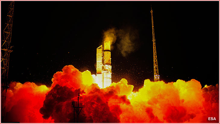
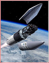
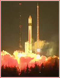
Rockot launches Sentinel-3A A veteran Soviet ballistic missile converted into a space launcher successfully delivered a European Earth-watching satellite for the world's largest environment-monitoring constellation on Feb. 16, 2016.
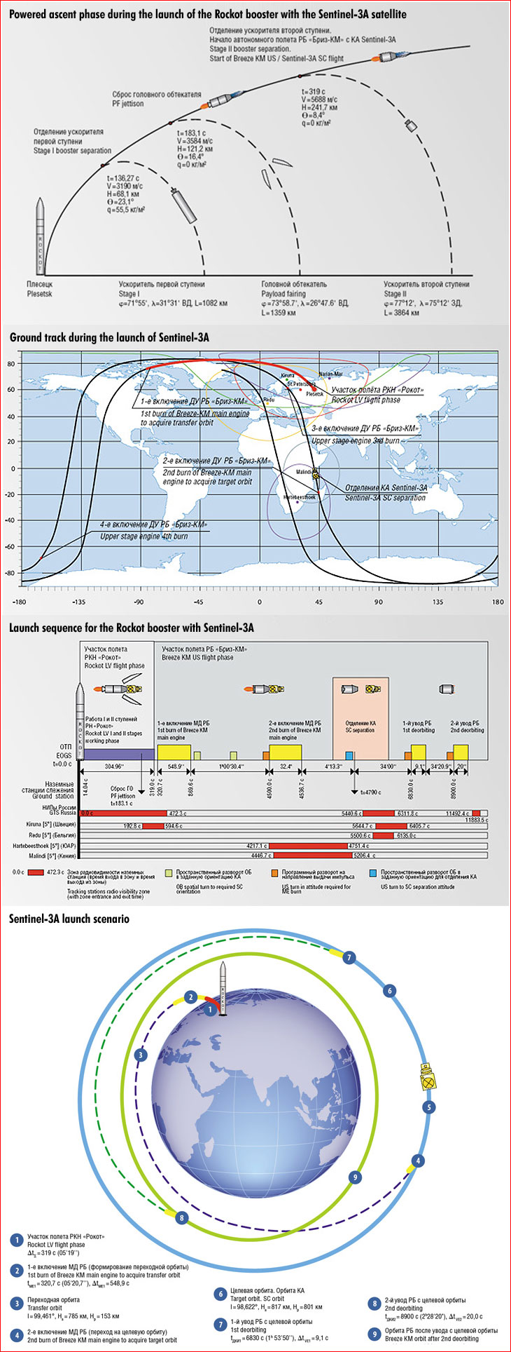
Flight profile The launch of the Rockot booster with a Briz-KM upper stage took place as scheduled on February 16, 2016, at 20:57:45 Moscow Time (12:57 p.m. EST) from Site 133 in Plesetsk. The vehicle carried the 1,250 kilogram Sentinel-3A satellite for the European Space Agency, ESA. After few seconds of a vertical ascent, the rocket headed northwest on the so-called retrograde trajectory, which will take the vehicle westward, unlike most orbital missions flying east with the rotation of the Earth. The ascent profile was designed to insert the satellite into an orbit extending from the North Pole to the South Pole of our planet. It enables remote-sensing satellites to observe the entire planet, as the globe makes a full rotation from west to east under the spacecraft's flight path every 24 hours. The first stage of the Rockot booster separated two minutes 16 seconds into the flight at an altitude more than 68 kilometers in the upper atmosphere. Then, more than three minutes into the flight, the payload fairing protecting Sentinel-3A split into two halves and fell off. The second stage continued to fire until 5.3 minutes into the flight, followed by the separation of the Briz-KM upper stage along with the satellite. The Briz-KM immediately fired its engine for more than nine minutes to insert the stack into a 785 by 153-kilometer initial orbit over the Arctic Canada. The vehicle then continued a unpowered climb for slightly more than one hour, interrupted only be a pair of short bursts of attitude control thrusters on Briz-KM to put the vehicle into desirable attitude. The third low-thrust firing of Briz-KM at 22:12 Moscow Time (2:12 p.m. EST) oriented the stage for the second and final major maneuver of the mission. By that time, the vehicle was near the highest point (apogee) of its elliptical orbit, where the main engine fired for 32.4 seconds to make the orbit circular at an altitude of around 817 kilometers. Minutes later, the stage oriented itself for the separation of Sentinel-3A around one hour 20 minutes after the liftoff. The European Space Agency confirmed the successful separation of the Sentinel-3A, as its ground station in Kiruna, Sweden, had received signals from the satellite. A few minutes later, ground controllers confirmed that the solar panel onboard the satellite had began deployment. Sentinel-3A was soon confirmed in good shape to beging flight testing. Following the separation of its payload, the Briz-KM stage was programmed to perform two maneuvers to enter a burial orbit, where it would not represent a collision threat for other spacecraft. Shortly after the rocket delivers Sentinel-3A into orbit, control of the satellite will be taken over by ground teams at ESOC, ESA's mission control center in Darmstadt, Germany. According to Sentinel-3 Mission Manager Susanne Mecklenburg, the first five months of the mission will be dedicated to testing to ensure that the platform and the instruments on the spacecraft are working well and are up for routine operations. During this period, some images and other information from the Sentinel's instruments will be released to expert users for a first feedback on the data quality. At the end of these initial five months, ESA intends to release operationally qualified level 1 Sentinel-3 core data products, and also a preview for some of the geophysical level 2 products. Once the commissioning is complete, the spacecraft will be handed over to Europe's meteorological organization Eumetsat for routine operations.
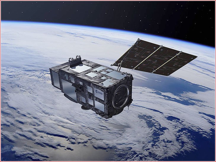
Copernicus system The Sentinel-3A is the first of two satellites within the Sentinel-3 series intended for monitoring land and ocean surface. Its imaging instruments are classified as medium resolution when compared to capabilities of more powerful satellites, however Sentinel-3 will be able to capture a wider swath of surface below its flight path than it would be possible with a higher zoom. The Sentinel-3A's optical and altimeter sensors will replace similar instruments on the Envisat spacecraft, while its capability to monitor vegetation will supercede the same function performed by previous-generation SPOT satellites. Sentinel-3A will be able to monitor the entire ocean surface, ice and land with optical instruments sensitive to multiple wavelengths. Besides traditional color photos, the satellite's payloads will be able to register surface temperature, while a special onboard altimeter will inform users about the topography of various surfaces. The thickness of sea ice could also be determined. Such characteristics as changes in sea level, marine pollution and biological productivity could also be determined. Last but not least, the satellite will be able to monitor the health of vegetation, detect fires and distinguish content in the atmosphere. In order to guarantee reliable delivery of satellite data as often as possible, each type of Sentinel satellite is designed to orbit the Earth along with its double. The Sentinel-3B satellite is expected to enter orbit on a Vega rocket within a year after its predecessor. In turn, the Sentinel-3 series is a part of a wider Copernicus project funded jointly by the European Commission, EC, and ESA. The project was previously known as Global Monitoring for Environment and Security or GMES. The first satellite in the constellation, Sentinel-1A, was launched in April 2014. Sentinel-2, launched on June 23, 2015, was designed to deliver high-resolution optical images for land services. Sentinel-4 and -5 will provide data for atmospheric composition monitoring from geostationary and polar orbits, respectively. Sentinel-6 will carry a radar altimeter to measure global sea-surface height, primarily for operational oceanography and for climate studies. In addition, a Sentinel-5 Precursor mission is being developed to reduce a time gap in data availability between the operation of the current Envisat satellite, and in particular its Sciamachy instrument, and the launch of new-generation Sentinel-5. The entire Copernicus constellation was designed to fulfill wide-ranging applications from environmental research to monitoring climate change and managing emergency situations. ESA called Copernicus the largest and most ambitious (space-based) environment-monitoring program in the world. Within the Copernicus program, the EC, acting on behalf of the European Union, is responsible for the overall initiative, setting requirements and managing the services. On its end, ESA manages all Sentinel satellites and serves users with satellite data available through the Sentinels and the Copernicus Contributing Missions at national, European and international levels. Design of the Sentinel-3A satellite
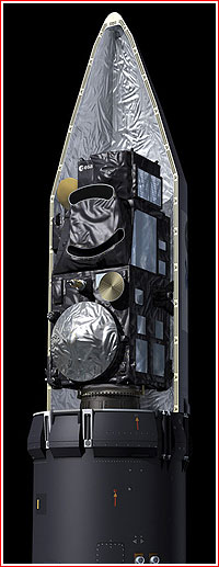
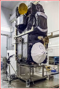
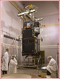
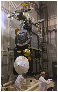
The Sentinel-3A spacecraft was designed to be compatible with light-weight launchers, such as Vega or Rockot. The satellite's box-shaped architecture was primarily driven by the need to provide a large surface facing space to effectively radiate heat from its systems. The spacecraft features modular design for payload accommodation and simplified management of all on-board interfaces. The satellite mechanical configuration and its flight attitude have been optimized through intensive mission analysis studies and system trade-offs in the course of its development, resulting in significant improvements in comparison to the previous-generation Envisat spacecraft.
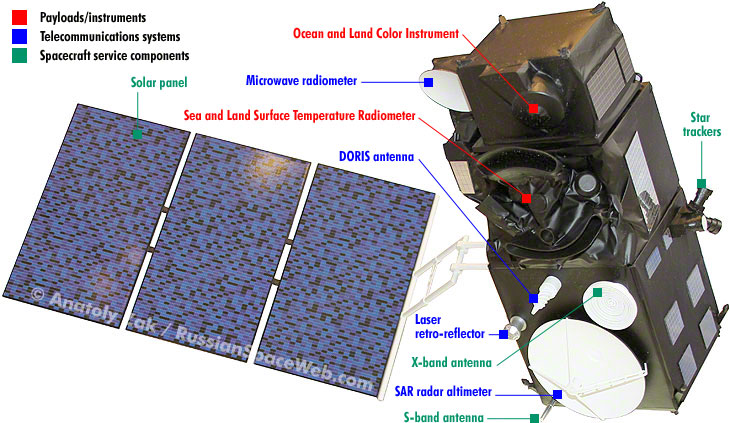
The satellite's service systems features gyroless, three-axis stabilized platform with three star tracker heads, four reaction wheels and magnetic off-loading for geodetic pointing and yaw steering. Eight one-newton hydrazine thrusters can be used for in-plane and out-plane maneuvers. The navigation system is capable of real-time on-board orbit accuracy determination of up to three meters, based on GPS and Kalman filtering. The power supply system features European-built gallium-arsenide solar cells and a lithium-ion battery with a capacity of 160 amperes per hour. Scientific data from the instruments can be transmitted to a ground station in Svalborg, Norway, while the telemetry to and from the satellite is routed via the Kiruna ground station in Sweden. Known specifications of the Sentinel-3A satellite:
Instruments on Sentinel-3A Thales Alenia Space France served as a prime developer for the satellite itself, as well as for OCLI and SRAL instruments. In the meantime, Selex ES of Italy provided the SLSTR radiometer, while EADS-CASA built the MWR radiometer. According to ESA, a total of 100 European companies participated in the development of the satellite. Citing its four-instrument payload, ESA characterized Sentinel-3 as the most complex satellite in the constellation. Ocean and Land Color Instrument, OLCI, covering 21 spectral bands (from 400 to 1020 nanometers). The instrument is based on heritage from Envisat’s Medium Resolution Imaging Spectrometer and features 21 distinct bands in the 0.4–1.02 μm spectral region (or 400 - 1020 nm) tuned to specific ocean color, vegetation and atmospheric correction measurement requirements. It has a spatial resolution of 300 meters for all measurements and a swath width of 1,270 kilometers, overlapping the SLSTR swath. OLCI’s new eyes on Earth will allow ocean ecosystems to be monitored, support crop management and agriculture and provide estimates of atmospheric aerosol and clouds – all of which bring significant societal benefits through more informed decision-making, ESA said. Sea and Land Surface Temperature Radiometer, SLSTR, covering nine spectral bands (from 550 to 12,000 nanometers), dual-view scan with swath widths of 1,420 kilometers, when satellites points directly down to nadir, and 750 kilometers, when the satellite scans behind its path. The instrument will measure global sea- and land-surface temperatures every day to an accuracy of better than 0.3 Kelvin. Continuing the legacy of Envisat’s Advanced Along Track Scanning Radiometer, it maintains a dual-view along-track-scanning approach and delivers measurements at a spatial resolution of 500 meters for visible/near-infrared and short-wavelength infrared channels and at one kilometer for thermal infrared channels. Furthermore, SLSTR includes two dedicated thermal infrared channels that are optimized for active fire detection and fire radiative power measurement, which is important for Copernicus Emergency Response and Climate Services. Synthetic Aperture Radar Altimeter, SRAL, works in Ku band (with a 300-meter resolution after SAR processing) and in C band. The synthetic aperture radar, SAR, altimeter is based on heritage from the CryoSat and Jason satellites. It provides measurements at a resolution of approximately 300 meters in the along-track direction after SAR processing and will be the first satellite altimeter to provide 100-percent coverage over all of Earth’s surfaces in SAR mode. Microwave Radiometer, MWR, with a dual frequency at 23.8 and 36.5 gigaherz. The MWR will support SRAL instrument to derive atmospheric correction and atmospheric column water vapor measurements necessary to reach the demanding performance requirements for Sentinel-3. The two latter instruments comprise the satellite's topography package promising to bring a step change in satellite altimetry, measuring the height of the sea surface, waves and the surface wind speed over the oceans. It will also provide accurate topography measurements over sea ice, ice sheets, rivers and lakes, ESA said.
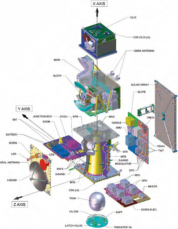
Key components of the Sentinel-3A satellite.
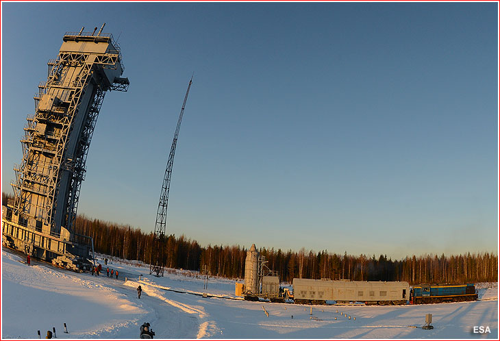
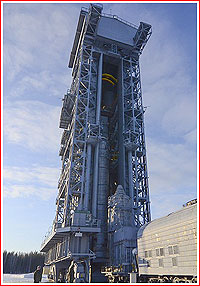
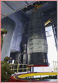
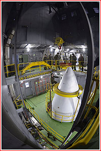
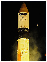
Internal architecture of the Sentinel-3A satellite. Credit: ESA Mission history At the beginning of 2014, the launch of Sentinel-3A had to be postponed from October 31 of that year. The mission was later rescheduled for June 2015 and by August 2015, it was planned on November 7, 2015. By October, the launch was postponed from Dec. 10 to Dec. 23, 2015. Sentinel-3A left Europe for Plesetsk in November 2015 and the Briz-KM upper stage arrived at the launch site at the beginning of December 2015. The launch campaign began in Plesetsk on December 4, with the unpacking of the satellite from its transport container. Still, in the first half of January 2016, the mission had to be postponed again to January 4, 2016, at 20:53:31 Moscow Time. In the second half of the same month, the launch was pushed back one more time to the second half of February 2016. At the beginning of February, mission managers finally committed to the launch on February 16, 2016, and the Sentinel-3A was fully fueled with its toxic propellants by February 4, marking the start of irreversible pre-launch operations. On February 8, 2016, the satellite was integrated with the Briz-KM upper stage. Next day, the satellite was covered with its protective fairing, forming the upper composite (or payload section) of the mission. The payload section arrived at the launch pad at Site 133 on February 12, 2016, and within next 24 hours was hoisted to the upper floor of the service tower and integrated with its Rockot booster.
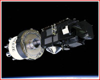
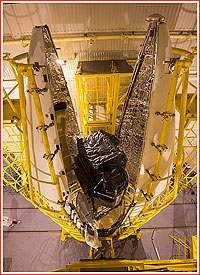
Payload section with the Sentinel-3A satellite arrives at Rockot's launch pad at Site 133 in Plesetsk on Feb. 12, 2016.
Read much more about the history of the Russian space program in a richly illustrated, large-format glossy edition:
|
IMAGE ARCHIVE
|
|||||||||||||||||||||||||||||||||||||||||||||||||||||||||||||||||||||||||||||||||||||||||||||||||||||||||