| |
|
|
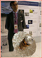
Soyuz rocket successfully launches Gaia satellite
A Russian-built Soyuz-2 rocket sent a European spacecraft 1.5 million kilometers from Earth on Dec. 19, 2013, on a ground-breaking mission to map the Milky Way. Besides its launch vehicle, the Gaia mission has little-known Russian roots.
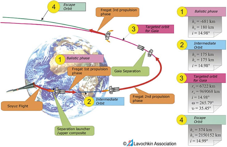
Mission scenario of a Soyuz rocket delivering Gaia spacecraft. Russian roots of Gaia In August 1989, the European Space Agency, ESA, launched its first astrometrical satellite named Hipparcos. It operated until 1993, essentially revolutionizing the field of astrometry with its data. Naturally, a number of proposals for a successor mission were made, however the core of the Hipparcos science team was too pre-occupied with the operation of the satellite and the subsequent analysis of its immense scientific harvest to really prepare for future missions. Still, in October 1989, Erik Høg, a leading scientist in the Hipparcos project from the Niels Bohr Institute in Copenhagen, made a presentation about the Hipparcos mission at a symposium of the International Astronomical Union, IAU, held in Leningrad (now St. Petersburg). During the same meeting, Soviet astronomers described plans for three astrometrical missions which were in development in the USSR -- Lomonosov, Regatta-Astro and Aist-Struve. At the time, they were promised to fly before 1997. The Regatta-Astro project conceptualized at the Space Research Institute, IKI, in Moscow would use a yet-to-be-developed spacecraft platform. It would orient itself in space with the help of a solar sail driven by the pressure of the solar wind. The scientific payload would use a wide-angle TV cameras with CCD detectors and photometers. As of 1989, Regatta-Astro was expected to fly in 1993 or 1994. It would tumble slowly at a rate of one revolution a day in a solar orbit between the Earth and the Sun, at a distance of 12 million kilometers from its home planet. (676) As it transpired later, the considerably larger Lomonosov space telescope would be based on the Arkon/Araks spy satellite, then under development at NPO Lavochkin. Finally, the Aist spacecraft would probably be developed specifically for the purpose of astrometry and feature a unique design. Soviet astronomers also invited Erik Høg to visit the Pulkovo Observatory located south of Leningrad, the mission control center near Moscow and the Kislovodsk Observatory in the Caucasus mountains in Southern Russia in August 1990. During the trip, Russian astronomers Mark Chubey from the Pulkovo Observatory, V.V. Makarov and V.N. Yershov described to Høg the concept of the Aist mission. Their ideas inspired Høg to draft a concept of the Hipparcos-2 satellite, which would be 10 times more sensitive to light, thanks to the use of more detectors, even though the aperture (or diameter) of the main telescope would remain the same -- just 29 centimeters. (674) At a meeting in Moscow in June 1991, where Høg was joined by another Hipparcos team member Michael Lennart, the group decided to join forces and merge the concept of the Soviet Aist satellite with the ideas for a follow-on satellite to Hipparcos. On July 18, 1991, at a symposium in Moscow, Høg and Chubey presented a proposal for a second Hipparcos satellite, which could fly in 1999. The spacecraft with a diameter of four meters would carry a telescope with an aperture of 40 centimeters. All the improvements would increase the star-mapping accuracy of its predecessor by 10 times. (675) The concept was given to the officials at the mission control center in Moscow, but, it was never been published. During the same year, Høg learned about the charge-couple device, CCD, technology, which could be used in astrometry instead of less sensitive photoelectric detectors installed onboard the original Hipparcos satellite. In September 1992, the Roemer spacecraft was proposed to take advantage of CCD. The satellite was named after Ole Rømer, a 17th-century Danish astronomer who developed a crucial astrometrical instrument. The Roemer spacecraft would have the same aperture of 29 centimeters as Hipparcos, but the telescope's focal length would be increased from 1.4 to 5 meters and feature CCDs. The resulting light sensitivity would be improved by 100,000 times! On May 24, 1993, 13 members of the Hipparcos' science team formally proposed the Roemer project to ESA to compete for the agency's third medium-size mission, or M3. According to the proposal, the Roemer satellite featuring a telescope with an aperture of 34 centimeters would measure the positions of 100,000 million stars with an accuracy of 0.2 milliarcseconds during a 2.5-year mission. The selection committee at ESA gave a high rating to the concept but postponed it until the future, since it had come too soon after Hipparcos. Later the project participants admitted that this delay gave them time to develop much better technology for a follow-on satellite. (674) In August 1994, at another IAU symposium, Høg proposed a more powerful astrometric satellite featuring a dual telescope with an aperture of 70 centimeters. It was dubbed Roemer+. At the same event, Lennart Lindegren and Michael Perryman proposed a spacecraft, which would use the method of interferometry for astrometry. It was officially dubbed GAIA, which stood for Global Astrometric Interferometry for Astrophysics. The proposal called for the use a pair of telescopes which would be larger and more powerful than a single instrument proposed for Roemer. In the meantime, all the Soviet concepts for astrometry missions collapsed with the USSR. Still, looking back at the contribution of Soviet astronomers, Høg wrote in 2011 that without their ideas "there would have been no Roemer or Gaia mission today." (673) Other proposals for astrometric spacecraft had also been made during the 1990s and 2000s. They included the American FAME-1, FAME-2, AMEX and MIDEX projects and the German-proposed DIVA. Another astrometric satellite was also considered in Japan. None of them made it to the launch pad. ESA approved the GAIA mission in 2000, even though the use of interferometry, which gave the name to the project, was rejected by January 1998. In 2003, it was decided to spell the name of the project in lower case as Gaia. Lobbying efforts by Høg in 2007 to appropriately rename the mission into Roemer did not succeed. (673) Various assessment studies of the Gaia mission followed and the active implementation of the project started with the selection of EADS Astrium as the prime contractor in the first half of 2006. Between 2007 and 2009, Gaia's launch was scheduled for 2012, however by May 2011, the mission slipped to May 2013. By August of that year, the launch was expected on Nov. 20, 2013. However on October 22, Arianespace announced that the Gaia satellite had required additional checks and ESA had requested to postpone the launch. On October 28, Arianespace confirmed that the launch was set for December 20. Known specifications of Soviet astrometric satellites (673)
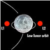
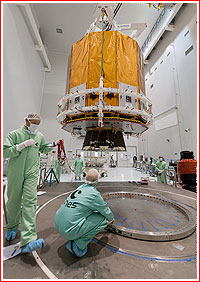
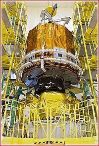
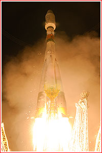
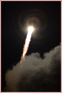
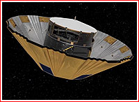
Gaia lifts off The launch of the Soyuz-ST-B (Soyuz-2) rocket with a Fregat upper stage took place as scheduled on Dec. 19, 2013, at 13:12:19 Moscow Time (04:12 a.m. EST, 06:12 local, 09:12 GMT) from the Soyuz launch facility in Kourou, French Guiana. The rocket boosted the 2,034-kilogram Gaia astronomy satellite toward the second Lagrange point located 1.5 million kilometers from our planet where gravitational forces of the Sun and Earth reach a shaky equilibrium. There, Gaia will start a five-year mission to catalog up to one billion stars as faint as the 20th magnitude within our galaxy. It was the 29th mission of the Soyuz-2 rocket and the 77th orbital launch attempt around the world in 2013. Gaia launch sequence on Dec. 19, 2013 according to ESA:
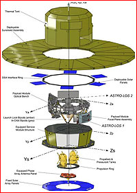
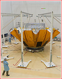
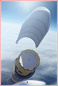
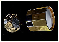
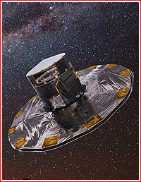
Path to orbit According to the launch scenario, immediately after liftoff from its South-American launch pad, the Soyuz headed across the Atlantic along the azimuth matching an inclination 14.98 degrees toward the Equator. The first three stages then inserted the payload section, composed of the Fregat upper stage and the Gaia satellite, into a ballistic trajectory slightly less than nine minutes after the liftoff. Shortly thereafter, Fregat fired its engine for two minutes and 16 seconds accelerating the stack to an orbital velocity and placing it into a 175-kilometer initial parking orbit. Some 21 minutes after the liftoff, the Fregat's engine fired again, this time for 15 minutes and 34 seconds, sending Gaia on its transfer trajectory towards the L2 Lagrange point. The separation between the spacecraft and the Fregat stage took place five minutes after the maneuver, or 41 minutes 59 seconds after liftoff. At separation, Gaia was expected to activate its radio transponder, attitude-control gyroscopes and release bipods connecting the payload module and the service module. The satellite's propulsion system will also be pressurized and ready for action. In the meantime, the Fregat was to conduct a third maneuver, (apparently with its attitude control thrusters), sending itself into a heliocentric "graveyard" orbit. One hour into the mission, Gaia was supposed to activate its thermal control system and orient itself correctly in space using the Sun as a guide. The critical deployment of the umbrella-like Sun shield was scheduled to begin one hour 18 minutes into the mission and continue for 10 minutes. It was to be followed by the deployment of a redundant system 10 minutes later. In its post-launch press-release, Arianespace, the company that oversaw Soyuz launches in Kourou, confirmed that Gaia's sunshield had been deployed in a 10-minute automatic sequence, completed around 88 minutes after launch. During Gaia's journey to L2, only small orbit-correction maneuvers are expected to be needed to negate small navigation errors. After a month-long transit flight, an orbit insertion maneuver will inject the spacecraft onto a stable orbit around the L2 orbit. According to Arianespace, tomorrow, engineers will command Gaia to perform the first of two critical thruster firings to ensure it is on the right trajectory towards its L2 home orbit. About 20 days after launch, the second critical burn will take place, inserting it into its operational orbit around L2, Arianespace said. Final operational orbit The Gaia satellite was built by a European space consortium Astrium for the European Space Agency. It was designed to operate in a Lissajous-type orbit, around the L2 point of the Sun-Earth system, which is located 1.5 million kilometers from the Earth in the direction opposite from the Sun. The spacecraft will be moving around the L2 point in a giant circle with a diameter from 340,000 to 90,000 kilometers, which will take on average 180 days to complete. In such an orbit, the spacecraft will avoid eclipses by the Earth, causing onboard temperature plunges, while at the same time it will be conveniently positioned to watch the sky in the opposite direction from the glaring sunlight and obstructions from the Earth and the Moon. It will also be far beyond the damaging effects of radiation belts of the Earth. Gaia will always point away from the Sun, its sensitive telescopes shielded by a 10-meter-wide circular sunshade that will unfold shortly after the spacecraft is deployed. This will keep Gaia’s sensitive telescopes and cameras at a cool and stable temperature below -100 degrees C to ensure the most accurate measurements can be made. The sunshade has another function: to generate power for the spacecraft. Since its underside will always be facing the Sun, its surface is partially covered with solar panels to generate electricity. Initial tests The mission to deliver and deploy the Gaia satellite in its operational orbit is known as the Launch and Early Orbit Phase, LEOP. It has a typical duration of two days. LEOP is to be followed by a month-long transfer and in-orbit commissioning phase, during which all operations allowing to prepare the operational phase will be performed. In particular, all science-related functions are to be thoroughly tested and calibrated, including the trials of small maneuvering thrusters and operations of science instruments. This phase is to be concluded by the insertion of the satellite into its operational orbit around L2 and will include any eventual orbit correction maneuvers, if necessary. Following final commissioning and calibration, the spacecraft is to be ready to enter the five-year operational phase, which could be further extended by one year. The spacecraft had onboard consumables for 6.5 years of operation. Gaia's scientific tasks According to ESA, Gaia mission was designed to produce an unprecedented 3D map of our galaxy by measuring, with exquisite precision, the position and motion of one billion stars, representing one percent of the stars in our galaxy. It was to be achieved thanks to a billion-pixel camera at the heart of the satellite's dual telescope system. From its orbit around the second Lagrange point, L2, of the Sun-Earth system, Gaia was to perform an uninterrupted scan of the sky. While the spacecraft would slowly spin with a period of six hours, Gaia's two telescopes would observe simultaneously two rectangular patches of the sky that are separated by an angle of 106.5 degrees. Each telescope has a large, rectangular primary mirror with a collecting area of about 0.7 square meters. Three curved mirrors and three flat mirrors focus and repeatedly bounce the light to each other over a total distance of 35 meters before it finally reaches the focal plane where the camera is located. Gaia's camera is equipped with three science instruments:
They were all based on digital detectors – charged coupled devices, CCDs, – that record light from astronomical sources. With a total of 106 CCDs, each consisting of more than eight million pixels, Gaia's camera boasted almost one billion pixels covering an area of 0.38 square meters – the largest focal plane ever flown in space. As Gaia spins, scanning great circles on the sky, the images of stars seen in its two telescopes move across the focal plane. Because of the data volumes involved, it would be unfeasible to read-out and store all the images recorded by the CCDs at any given time. The sky mapper is used to identify a subset of astronomical sources to be measured. The largest science instrument on the focal plane is the astrometric field, which contains eight columns with seven CCDs each and one column with six CCDs. As a window moves across the columns of the astrometric field, the output from each CCD that the source has crossed is accumulated, read-out and stored. These data are crucial to calculate the position of stars and other astronomical sources to unprecedented precision. After the astrometric field, the starlight passes through two filters that direct different wavelengths to the two columns of CCDs in the photometer: the first column receives light with shorter wavelengths (from 330 to 680 nanometers), and the second column receives light with longer wavelengths (from 640 to 1050 nanometers). The resulting spectra can be used to determine the temperature, age and other properties of stars. The final instrument to analyze the sources was the radial velocity spectrometer, which consisted of three columns with four CCDs each. Since this has a smaller 'footprint' than the other instruments, only astronomical sources that crossed the four lower rows of CCDs in the previous instruments would fall also on the radial velocity spectrometer. Lenses, prisms and a grating plate reduce the light to a very narrow band - between 845 and 873 nanometers - and provide a spectrum which encompasses three absorption lines of ionised calcium, known as the Ca II triplet lines. These absorption lines are recorded as dips in the source's brightness at a given wavelength: the difference between the observed wavelengths of a line in a star and the corresponding wavelength at which the same line is observed in the laboratory allows astronomers to estimate a star's radial velocity - the line-of-sight velocity with respect to Gaia. For each source, all the information that has been recorded by the CCDs is compressed into a data packet and stored on board. The data packets are transmitted to Earth at a rate of about 8.7 Mbit per second, where they are received at ESA's ground stations in Cebreros, Spain; New Norcia, Australia; and Malargue, Argentina. Once these raw data reach Earth, they are ready to be processed by the Data Processing and Analysis Consortium, DPAC, who will take care of turning them into scientifically-useful data, according to ESA web site. Gaia's operation Gaia builds on the global astrometry concept successfully demonstrated by the Hipparcos mission launched in 1989. This measurement principle relies on the systematic and repeating observation of the star positions in two fields of view. For this purpose, the spacecraft is slowly rotating at a constant angular rate of one degree per minute around an axis perpendicular to those two fields of view, which thus describe a circle in the sky in six hours. With a basic angle of 106.5 degrees separating the astrometric fields of view, objects transit in the second field of view 106.5 minutes after crossing the first one. The spacecraft rotation axis makes an angle of 45 degrees with the Sun direction. This represents the optimal point between astrometry requirements - that call for a large angle - and implementation constraints - such as payload shading and solar array efficiency. This scan axis further describes a slow precession motion around the Sun-to-Earth direction, with an average period of 63.12 days. This allows the scanning law definition to be independent from the orbital position around the L2 Lagrange point. In some regions of the sky, like the Baade's window, Omega Centauri or other globular clusters, the star density exceeds 750,000 per square degree the storage capability of the onboard processors. In these cases, a modified scanning law may be temporarily followed in order to increase the number of successive transits in these regions. From July 24, 2014, to Jan. 15, 2025, Gaia made more than three trillion observations of two billion stars and other objects, producing around 500 terabytes of data, which resulted in around 13,000 scientific publications, according to ESA. By early 2025, the Gaia satellite expended 55 kilograms of nitrogen gas from its attitide control system, requiring to end its scientific operations ahead of a series of engineering tests and the move to a burial heliocentric orbit for "passivation" operations at the end of its mission scheduled for March 27, 2025. At the time, the fourth and fifth releases of data gathered by the satellite were scheduled for 2026 and 2029. Known specifications of the Gaia spacecraft:
|
|